One of life’s more mysterious delights is synchronicity, those moments when you experience a startling coincidence that impresses your instinct as having special meaning that may defy logic. I’ve been enjoying several of these “whoa” moments with respect to El Camino Real since I started this project.
Here’s an example. The afternoon of September 25, 2006 I read the landmark article “What Is Web 2.0” by Tim O’Reilly. It had been written a year earlier, but I’ve always been behind in all things web. I read it, I “got” it, and was inspired to create a web site as a way finally to express this ticklish notion I’ve had for a while of celebrating El Camino Real. The name came to me like a thunderbolt: AllCamino.com. Later that evening I was browsing the San Jose Mercury News online and was astonished to read an article published that same day called “Bringing face-lift to historic road” which was all about the Grand Boulevard Initiative of Joint Venture: Silicon Valley Network, a multi-city drive to revamp El Camino into a unique, thriving street for the 21st century. It was fate; it reinforced that El Camino has a story to be told. I registered the domain name immediately.
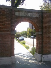 Here’s another. I registered the domain in 2006 but didn’t get around to creating this blog at the site until August 11, 2009. (I told you I’m always behind.) I accomplished this milestone with my laptop at the San Jose Library Rose Garden branch using their free wi-fi. After creating the blog, to celebrate I drove up Naglee Avenue and down The Alameda to Tee Nee Thai for lunch. On the way I happened to see the Hester Park gates at Singletary Avenue. I had never noticed them before and I wondered what “Hester Park” meant. Was there really a park? Aha, an El Camino mystery to investigate! So after lunch I walked back up to Singletary and took some photos of the gates. I walked down Singletary several blocks to look for a park. I didn’t find one so I turned right on Park Avenue, passed Hoover Middle School and the Egyptian Museum, turned right again at Naglee and walked all the way back up to The Alameda, a big loop. Then inspiration struck again. Since it was a beautiful day I decided to walk the entire length of The Alameda from that point all the way down to the Caltrain underpass and back. That day I “did” The Alameda; what better way to celebrate the launch of AllCamino? An ice cream cone from Schurra’s consecrated the occasion. My walk all started with that happenstantial glimpse of the Hester Park gates; none of it was planned, I just followed a series of whims. A few months later in January 2010, I was studying an old map of San Jose and realized that Singletary Avenue wasn’t always called that; it used to be called Moore Street after Judge John Hendley Moore who owned that land. My last name is Moore, no relation to the judge. So yeah, without knowing it I marked the beginning of my El Camino career at the intersection of Moore and The Alameda. Mind-blowing. Did I mention there’s a bell right there? As a humorous postscript, I discovered there is no Hester Park on Singletary/Moore after all; that was the name of an old housing subdivision there. However I did find an actual Hester Park very nearby…a teeny tiny playground adjacent to the San Jose Library Rose Garden branch, the very same branch where I launched this blog. Ba doom, crash!
That’s all kid stuff. Here’s synchronicity’s grandma with respect to El Camino Real and me.
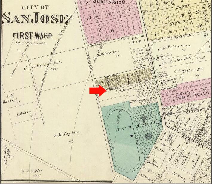
Shortly after I launched the blog I went looking for books about El Camino, or at least with “El Camino” in the title. I bought two for their distinctiveness: Deep California: Images and Ironies of Cross and Sword on El Camino Real by Craig Chalquist, PhD, and California’s El Camino Real and Its Historic Bells by Max Kurillo and Erline Tuttle. The latter contains a reproduction of a 1912 AAA road map showing the length of El Camino from San Diego to San Francisco. It answered a mystery for me. El Camino nominally links the missions, but Mission San José in Fremont is nowhere near today’s El Camino Real. So what route did early Californians take from Mission Santa Clara to Mission San José? I had assumed the route ran down The Alameda to Santa Clara Street in San Jose to Alum Rock Avenue, perhaps running north along the foothills on Piedmont Road. The 1912 map suggested something different. It shows El Camino entering San Jose from the south as Monterey Road/First Street then splitting. One branch goes west to The Alameda as expected, but the other branch continues along First Street then turns east somewhere around Gish Road, then turns north on Old Oakland Road. There it continues along Main Street and Milpitas Boulevard in Milpitas, to Warm Springs Boulevard in Fremont, to Mission Boulevard which runs right to Mission San José. So there’s the route, which I like to call El Camino de San Jose.
Here’s the thing. I live on Old Oakland Road. I live on El Camino de San Jose.
I’ve lived there for over ten years. I had no idea about its mission connection. This knowledge did not inform my decision to buy the house, nor did it impact my interest in El Camino Real or motivations to start the blog. I had always assumed Old Oakland Road was simply the old road to Oakland, later replaced by Interstate 880, and never thought more about it than that. To tell the truth I had been feeling naggingly incomplete blogging about El Camino when I didn’t actually live or work on it. I didn’t have standing. But guess what, I do after all and I learned all this after the fact. Astounding.
A 1912 map is pretty old, but it’s a lot more recent than 1797 when Mission San José was founded. I embarked on a quest to find older maps that show this road. I bought a bunch of well-known San Jose maps from eBay, Lord help me. The David Rumsey Historical Map Collection has also been helpful, however the Online Archive of California, in particular the UC Berkeley Bancroft Library collection, has been absolutely indispensable in this research. They have high-resolution scans of the California land case maps, evidence the Mexican rancho owners presented in their petitions to the U.S. government for the rights to the land. “Transfer” of land ownership is of course the fundamental moral, ethical, and legal quandary in California’s past, but the records generated shed light on state history. The following two maps are the keys for me to El Camino de San Jose.
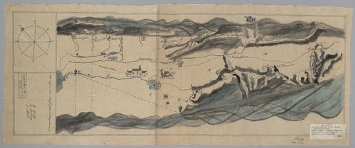
The first is a free-hand map or diseño of North San Jose dating from the 1840s. I first found it in the Historical Atlas of California by Derek Hayes. It clearly shows “El Camino Nacional” (in some maps the name changed from “Real” (“Royal”) to “Nacional” (“National”) to reflect Mexican independence from the Spanish crown) running to the San Jose pueblo from the south, then branching off as “El Camino de San Jose” to the north in the direction of the mission which unfortunately is not shown. This camino crosses Coyote and Penitencia Creeks (“Arroyo de Collotes” and “Arroyo de la Penitencia“), and I contend that this road is Oakland Road today. Oakland Road still crosses Coyote Creek in front of the San Jose Municipal Golf Course, and it used to cross Lower Penitencia Creek in front of Orchard School before the creek was radically altered into submission.
The next map shows only Milpitas, but this time it’s an official survey from 1857. It’s so dead-on accurate I can overlay it on a modern map and details like roads and historic buildings line up perfectly. It’s irrefutable that the road labeled “San Jose Road” on the survey is Oakland Road today. It hasn’t moved in over 150 years.
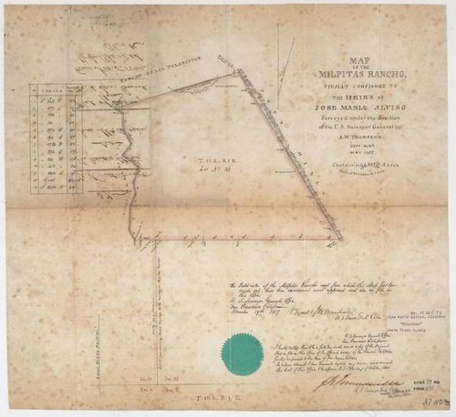
To recap, my thesis is that at least as far back as 1797 the Spanish must have had a road that connected Mission Santa Clara and the San Jose pueblo with Mission San José, and that Oakland Road today is part of it. The 1840s rough diseño shows such a road labeled “Camino de S. Jose” that approximately corresponds to physical features of Oakland Road. It unfortunately doesn’t show Mission San José but there’s a suggestive ambiguity in the name “Camino de S. Jose;” it’s the perfect name for a road connecting Pueblo de San José to Mission San José. It’s reasonable to conclude that “Camino de S. Jose” on the diseño is “San Jose Road” on the 1857 survey; it’s a direct Spanish-to-English translation. The survey proves topographically that San Jose Road then is Oakland Road now, and that’s where I live.
I’m no historian so I can’t say how much proof is proof enough, and I recognize there are holes in my maps. For example on the diseño the road crosses Penitencia Creek at the wrong spot, but I’m willing to attribute that to either map error or shifts in the creek over time. On the other hand, I’ve read at MilpitasHistory.org and other sites that Penitencia Creek was so named because the padres from Mission Santa Clara and Mission San José would periodically meet in an oak grove along its bank and give penance to each other and to the native Ohlone. I’m writing a song about it:
How’d the padres get to San Jose?
They drove on Oakland Road, and stopped to pray along the way…
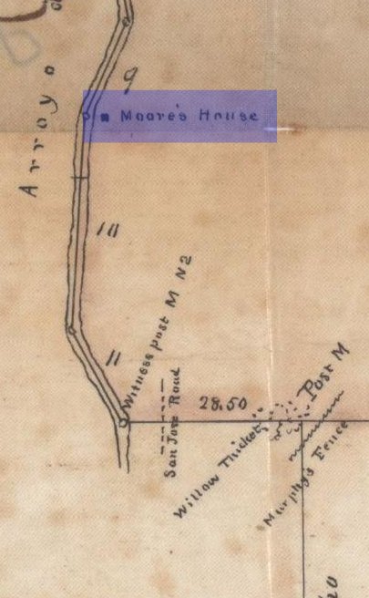
So I’m convinced. And if that weren’t enough, this little detail from the southwest corner of the property in the 1857 survey grabbed my attention and drove the point home to me.
Synchronicity. It’s a trip.
I have a much deeper personal connection to El Camino Real than I ever realized or may ever understand. So far it’s been fun and exciting, the experience of a lifetime as I try to hear what it’s saying to me. I will henceforth widen the scope of this blog to include the historic East Bay as well as the Peninsula. I look forward to following this road. Who knows where it goes?
I have enjoyed reading your story. You have obviously done much research toward the mystery you seeked to solve.
I am writing in search of answers also. I am looking for what would have been an intersection on the old El Camino Real that would have been with a major road 1 mile north or 1 mile south of what would have been at that time, Pueblo de San Jose. I am particularly interested in one that was important enough to have a bell marker and sign. I am assuming that Pueblo de San Jose was on the El Camino Real road or at least very close to it. I have been looking for an old map from the time when Calif Auto Assn. or AAA launched its campaign to erect signs along the El Camino Real it would be on there. I do not know when that was done but I am guessing it was in the late 20s to 30s, 1928 maybe. If you have a list of where the original signs were placed that would be even better than a map alone.
I hope you can help me find the answers I seek.
Regards,
Chris
Hi Chris,
Thanks for the question! I can recommend the book “Californias El Camino Real and Its Historic Bells” (linked to in the post above). It has AAA maps from 1912 and a list of installed bells. The maps are great, but they are very small and don’t have much detail. I wouldn’t say the list of bells is comprehensive, but it does document the earliest bells really well.
From your description, it seems likely you’re referring to the bell at Cadwallader Park in San Jose at the intersection of South First, South Second, and Humboldt streets. Here’s what the book says:
Date: Sept. 10, 1909
Donors: Native Sons of the Golden West and Native Daughters of the Golden West
Location: The fourth bell to be erected in the immediate vicinity of San Jose, southernmost point of Cadwallader Park, First and Second Streets
Date: Sept. 11, 1910
Donors: Vendome, No. 100 (Native Sons of the Golden West)
Location: Cadwallader Park, San Jose
Maybe something happened to the first bell so they erected another a year later. This park is a little “gore” park, one mile south of San Carlos St. which is roughly the southern border of the Pueblo.
About one mile north of the Pueblo, First Street intersects with Taylor, Hedding, and Gish streets which were probably pretty important intersections 100 years ago. Unfortunately I don’t have any information about bells being located there.
Hope this helps, from one seeker to another!