On Saturday, October 2 I drove down to Morgan Hill to attend a community meeting planning a redesign of the stretch of Monterey Road which passes through downtown. The initiative is dubbed “A New Downtown” and is currently in the planning stages, accepting community input on ways to improve the appearance, strengthen the identity, and support the businesses on Monterey Road. This was only the third time I had ever been to Morgan Hill outside the confines of US-101 so I took the opportunity to try and make the acquaintance of our South County neighbor. Downtown was charming, but it was the residents who made a distinct first impression I’ll always remember.
For those unfamiliar with Morgan Hill, as I must admit I was, it’s a small town of 33,000 residents (as of 2000). I always thought it was adjacent to San Jose but I just learned as I’m writing this that there’s an unincorporated town called Coyote in between. Who knew? If there’s one thing you need to know about Morgan Hill, it is this: there is no hill there named Morgan. The town is named for a fellow named Hiram Morgan Hill who eloped with the granddaughter of Martin Murphy in 1882. Their ranch on Monterey Road, inherited from the Murphys, was often referred to as “Morgan Hill’s Ranch” and the name stuck for the railroad depot and town which developed around it. The name is ironic because the most visible 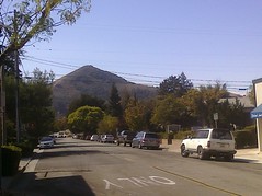 natural feature of the area is a large hill west of downtown called El Toro, but which uninformed visitors would naturally assume to be the town’s namesake.
I drove down US-101 to get there. I needed gas so I hopped off the freeway an exit early to fill up which worked out well because I could cruise into town on Monterey Road which I consider to be El Camino Real in South County. CalTrans put El Camino Real bells on US-101 down there but there’s no question they missed the mark. Monterey Road was exactly that, the historic road from Monterey to San Jose and by extension, from Mission San Carlos Borromeo in Carmel to Mission Santa Clara.
As I drove through downtown Morgan Hill, I was met by a surprise: a couple political demonstrations on opposite sides of Monterey Road at Third Street. One was very quiet: four ladies dressed in all black simply standing and holding signs promoting peace and a desire to bring the troops back home. The other was larger and louder with people waving anti-Democrat and anti-incumbent signs: a Tea Party.
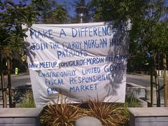 I had never witnessed a Tea Party rally so I parked my car and went down to check it out. Tea Partiers are of course politically conservative activists who have become known for their energetic demonstrations and activities in the last year or so. The group I saw are the Gilroy-Morgan Hill Patriots and they will be holding these Saturday rallies until the election on Tuesday, November 2. One of the sign-waving Patriots, a woman named Jean, saw that I was carrying a community meeting packet so we got into a pleasantly civil conversation about past and proposed Monterey Road development in Morgan Hill such as the newly renovated intersection at Third Street where we were standing. She expressed concern about tax dollars being spent on wasteful projects and about the evils of eminent domain. Her opinions were of course valid and reasonable and included important issues which need to be addressed in public affairs. I’m politically liberal and have found many national Tea Party positions dangerously extreme and objectionable, spanning the gamut from sinister to cynical to ridiculous. So my first face-to-face Tea Party encounter was refreshingly palatable and even beneficial. Are Bay Area conservatives kinder and gentler than their counterparts elsewhere? Or is Jean just a moderate exception? It’s difficult to say. She did express to me that her participation in the Tea Party is motivated by desire for fiscal responsibility, not race. I’m sure she was anticipating concerns I might have had (she was right; I did) and I believe her sincerity. Still I wonder if she doth protest too much.
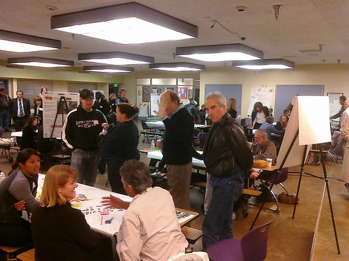
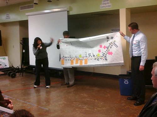
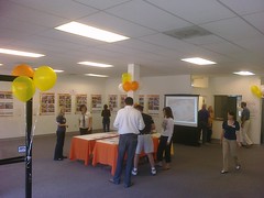 By the time I finished talking with Jean the other, quiet vigil was over so I didn’t get to talk with them. I suspect they were the Gilroy Women in Black, part of an international movement of women who demonstrate silently for peace and justice. It was time then to put politics aside. I headed back to the repurposed storefront where the community meeting was being held to contribute my two cents. The meeting was not a meeting per se but rather a self-paced gathering of input on ways to improve the street. It was hosted by the city and staffed by individuals from Callander Associates, the urban design firm facilitating the planning process. They had different stations where we could share broad ideas on what constitutes a successful and unsuccessful downtown, and where we could vote for our favorite proposed changes.
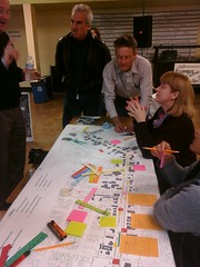
 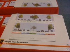 The best activity involved a scale drawing of a Monterey Road cross-section over which we could lay design elements of different sizes such as sidewalks, parking and traffic lanes, and landscaped medians. The challenge was to get everything to fit. Wide sidewalks, bike lanes, and a median large enough to hold a coffee kiosk would be wonderful but if it’s not going to fit, it’s not going to happen. I thought Jean would have liked that exercise in spatial responsibility. My end solution was to widen the sidewalk, shrink the existing median, and give up on having a bike lane.
They provided a free lunch. There is of course no such thing so while I was enjoying my roast beef sandwich from Ricatoni’s Delicatessen, I felt obligated to fill out an extensive questionnaire about everything from street parking configurations to my purchasing habits. I felt a little out-of-line making suggestions for a downtown I don’t live in but then I reminded myself that as a tourist my input was valuable. Downtown Morgan Hill has plenty of shops and restaurants that I’m sure would love to attract visitors from out-of-town. Their Tea Party isn’t racist, so I doubt the chamber of commerce is xenophobic.
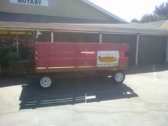 My last assigned task in the process was to take a walk up and down Monterey Road and complete an additional questionnaire along the way. As if the “free” lunch weren’t enough, they also gave me a voucher for a free ice cream cone from BookSmart a block off Monterey Road. Full disclosure: it was the enticement of free ice cream which drew me to the community meeting in the first place. I brilliantly opted to get my ice cream up front and enjoy it during my walk so a short detour to BookSmart was my first stop. In front was a gigantic red pull-wagon which gave me a hint what was inside. BookSmart is a fun place with loads of books, educational toys, a small cafe, and of course an ice cream counter. I ordered a scoop of tin roof sundae on a sugar cone, left a tip, and made my way back to and down Monterey Road.
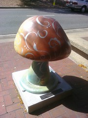 On my walk I enjoyed surveying the downtown businesses, scanning a few menus and shopping in a few windows as I went. I tried picking out with a critical eye design features I liked and disliked about Downtown Morgan Hill. I liked the abundance of trees, the visual variety and interest of the architecture, and the authenticity of the place, being heavy on small local businesses and light on generic national chains. I disliked the narrow sidewalks, some unsafe-feeling pedestrian crossings, and the relative lack of racial and cultural diversity in the population and businesses. I was ambivalent about the street art: a series of whimsically decorated fiberglass mushrooms up and down the street. I generally enjoy this type of civic icon pop art which has been quite popular for the last decade, but simply put I hate mushrooms, so there. I was happy to see that a farmer’s market was going on at Third Street, the apparent edge of Downtown. On the whole the street seemed cozy, well-apportioned, and thriving. I didn’t see anything blatantly amiss, but there’s always room for improvement.
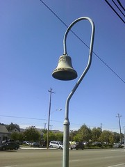 I finished my walk, turned in my questionnaire, entered a drawing for some local goods and services (apparently I didn’t win), and bade farewell to Downtown. I have now participated in El Camino redesign community meetings in three different cities, the others being Menlo Park and San Jose. I think that officially makes me an El Camino wonk. On my way out of town I stopped at the Morgan Hill House, the former residence of the aforementioned Hiram Morgan Hill and his bride Diana Murphy. It’s now home to the Morgan Hill Historical Society. I stopped to take pictures of the El Camino Real bell in front, the only one I saw on Monterey Road. At the community meeting I actually recommended adding more bells downtown to enhance the historical identity. Someone has to represent the Royal Road! I suppose that makes me a special interest lobbyist.
I told you this was my third visit to Morgan Hill. The first was for a child’s birthday party many years ago during which I saw very little of the city. The second was earlier this year when I took a long drive up Monterey Road all the way from San Martin up to San Jose with the specific intention of laying rubber and eyes on the South Valley El Camino. That was when I first discovered the unexpectedly inviting Downtown stretch. I literally just passed through (though I did stop at an ATM) but I liked what I saw and made plans to return. This most recent visit was gratifying as I got to interact with residents, dabble in local politics, and even sample the ice cream. Having taken a deep dive into Downtown, the old cliche proved true: the third time’s the charm.
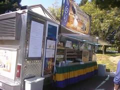 I’ve been on a little hiatus since Christmas but yesterday was 1/11/11 which I have on good authority is an auspicious time for new beginnings. Let’s get it started! Yesterday for lunch I stopped by the Louisiana Territory Cajun food truck for a Po’ Boy, selecting a “Pepper Picker” with sausage and peppers and onions and special sauce. Mmm…so good! This truck has serious El Camino cred and is a friend of this blog. My new buddy Cherie who manages the truck hipped me to this article in Metro last week about The Alameda. I hadn’t seen it. Thanks, Cherie! [Update: corrected to spelling of Cherie’s name.]
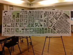 Then he goes on to gripe a bit about the plan, the 100-page document BMS Design Group produced after studying current conditions and collecting community input. Singh’s biggest concern is that the plan will drive out the funky eclecticity of the Town Center stretch south of Lenzen by imposing homogeneity with matching lampposts and coordinated newspaper racks. I think his fear is unfounded. It’s not like some developer is razing the buildings to the ground and building from scratch because then, sure, you might end up with something like Santana Row which is perfect and commercial but inauthentic. The whole purpose of the community meetings was to hear from the people who live and work there what needs to be fixed (traffic!) and what needs to be preserved (bells!). I was very pleased with how BMS ran the meetings and I am more than satisfied that the plan captures the soul of The Alameda. All the technical details are designed to make the Town Center a more accessible and inviting place that will draw visitors and impart to them the special and historic character of the place.

 The city of Milpitas has a


 I’m certainly not happy to see the tunnel go. I love the idea of the little critters scampering safely across the busy road through the thoughtfully-provided underpass. El Camino is a great way to go North and South, but it does have this tendency to split land in half, to separate East from West. It’s pretty easy to cross by car; I heard once that the intersection of El Camino Real and San Tomas Expressway in Santa Clara is one of the busiest intersections in the Bay Area. But for everyone else, crossing El Camino can be an ordeal. In 1928 the city of San Jose built a pedestrian subway tunnel under The Alameda for the students of Hester School to use. The subway is dedicated to the memory of Virginia A. Frazer and Charles Loring Sykes, two students who were struck and killed by automobiles while crossing the road. It was commendable of the city to take action to prevent another tragedy. San Diego should take note.

 Continuing with the rail theme today, the
