Archive for the ‘transportation’ Category

An El Camino Stretch

Friday, June 17th, 2011

Like any good blogger I have a news catcher that sends me alerts when stories crop up about my topic of choice, “El Camino.” Most stories are about our California road, but sometimes other subjects find my inbox, like this: starting Monday, June 20 a stretch of El Camino Real is going to be closed by construction crews for four months in the Bay Area. That’s the Galveston Bay Area. In Houston, TX. Sucks for them.

Occasionally I catch stories about the famed Chevrolet El Camino car/truck hybrid, usually sourced from car news and gossip site Jalopnik.com, and they’re typically pretty entertaining. Jalopnik loves them some ‘Mino and it shows. This week they posted an ad for a modified El Camino for sale in Detroit on Craig’s List, and it leaves me speechless. The owner stretched the truck bed, added another rear axle, and made various other cosmetic “enhancements.” Wow. Quite possibly the ugliest vehicle I have ever seen. Plus, he got the Ackermann geometry all wrong. I mean, geez.

StretchElCamino

I’m being unnecessarily mean. It may not look like much but I acknowledge it’s quite a feat of automotive engineering and craftsmanship and the owner claims it runs great, so kudos for that.

Kudos also to Jalopnik for dropping some real El Camino science in their writeup:

El Camino Real, or the Royal Road, refers to the 600-mile long padre path spanning San Diego to San Francisco, and interconnecting the California Missions. The builder of today’s Chevy El Camino with seis ruedas was obviously on a mission – a mission to make this the most El Camino-ist El Camino in the whole PBR-drinkin’ world.

True that.

[Source: Jalopnik]

Bear Flag Revolt

Tuesday, June 14th, 2011

This past weekend my wife and I skedaddled to Sonoma for a romantic getaway to celebrate our wedding anniversary. My first priority of course was to bask in her company and to enjoy the chic yet homey North Bay town. However, on the way up I confessed to Paulette that, you know, if on a stroll around the Plaza we just happened to stop by the mission for a minute and maybe take a quick look around, well, that would be pretty cool, wouldn’t it? She said, “riiight.” Am I that transparent?

CIMG0749

Mission San Francisco Solano in Sonoma is in fact a very special mission. It was the final mission established and the northernmost one in the chain. It was founded so late, 1823, that the missions weren’t even outposts of Spain anymore. By that time Mexico had declared its independence from the motherland and Alta California was Mexican territory. Sonoma is literally and historically where El Camino Real ends. There are historic El Camino Real bell markers on Broadway, SR-12, the road that leads right into the heart of town. CIMG0755Saturday, June 11 was International Yarn Bombing Day so the bell in the Plaza was charmingly bedecked with hand-knit California Poppies by a tagger who blogs at knitibranch.com.

I mentioned to Paulette that there were two things I wanted to explore while in Sonoma. The first was a question: how did the padres travel from San Francisco to Sonoma? There was no Golden Gate Bridge to span the mouth of the Bay and the tides there are too treacherous for easy crossing. As coincidence would have it, in our hotel room was the Spring, 2011 edition of Sonoma Magazine which was all about…water! In his article titled “Coming to Sonoma by Water,” Gerald Hill confirmed that Padre José Altamira deliberately sited the mission near Sonoma Creek so ships could sail passengers and cargo from San Francisco into San Pablo Bay up the slough to an embarcadero. “A bridge over the gate was more than a century away, roads were primitive and at times impassable, there was yet no railroad nearby, so in every real sense, the road to Sonoma was water.” El Camino de Agua?

CIMG0802The second thing I wanted to explore was the famous Bear Flag Revolt monument in the Plaza. There, in a coincidence beyond coincidence, we hit pay dirt. That very Sunday, June 12, happened to be the day Sonoma was holding their annual Bear Flag Revolt Celebration. We couldn’t have picked a better time to visit.

The Bear Flag Revolt is a quirky chapter in California history. In 1846 Alta California was still Mexico but it hosted numerous settlers from the United States. Relations between the Mexican government and the Americans were strained over issues of land claims, property ownership, and religion. The recent struggles in Texas were fresh in minds of the gringos who remembered all too well the Alamo. On June 14, 1846—165 years ago today—thirty-three armed Americans stormed Sonoma, took the local Mexican commander Mariano Vallejo prisoner, and pronounced themselves free of Mexican rule. They weren’t authorized to do this in the name of the United States, so they declared California to be a new democratic republic. They raised in the Plaza a hand-painted flag of their own design featuring a lone star in Texas’ honor, a grizzly bear, and the words, “California Republic.” That flag is the basis of the modern California flag flown today. The revolt lasted 25 days after which the U.S. Army arrived and raised the Stars and Stripes. Unbeknownst to the Osos (“bears” in Spanish), the United States had already formally declared war on Mexico and California was on the verge of changing hands yet again.

Happily the brief Sonoma revolt was bloodless; no one on either side was harmed. General Vallejo did catch malaria in captivity but he eventually recovered. History looks fondly on the Bear Flag incident, I think because there is something half-baked and frankly whiskey-soaked about the whole affair. It is after all in the heart of wine country. The revolutionaries were audacious but ultimately successful, and I imagine they fancied themselves Western sons of the Founding Fathers as they played their parts in the unfurling of Manifest Destiny.

So now, every year (off and on) the Native Sons of the Golden West Sonoma Parlor #111 commemorate the Bear Flag Revolt with a festival in the Plaza, traditionally with barbecued chicken dinners. After a whirlwind tour of the mission, Paulette and I stood in the shade around the amphitheater and watched the citizens reenact the revolt with a costumed, scripted play. Well, most of it was scripted. The locals in cowboy hats who portrayed the uprising mob mostly ad-libbed, punctuating dialogue with hearty “Hyahs!” as they fired blanks into the air from their period replica firearms. All the participants clearly enjoyed themselves and so did we.

CIMG0805

CIMG0808

CIMG0791

Lost in Los Altos

Tuesday, May 17th, 2011

Do you know what’s embarrassing? Getting lost on El Camino Real. I don’t mean “lost” in the poetic sense, as in getting so enraptured by the sights and wonders that I lose all sense of time. I mean “lost” as in not having a perfectly clear notion of either where I am, where my destination is, or the precise relationship between the two. “How could you possibly get lost on El Camino?” you protest. “It’s a street, a one-dimensional line!” This is true, but after 200 years the road has developed a few idiosyncrasies which can snare the unwitting traveler. One of them is the city of Los Altos.

Border Road

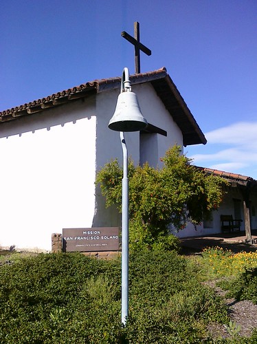
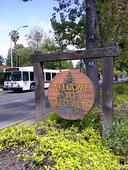
The first tricky thing about Los Altos is something that residents know but it took me a while to figure out: Los Altos does not cross El Camino Real. The city flows down from the hills but in its northernmost section it abuts El Camino. That means if you’re driving down El Camino, Los Altos exists only on one side of the street. El Camino borders Los Altos for about a mile and a half.

This is unusual. As far as I can determine, there’s only one other city in the Bay Area that touches but does not cross El Camino: Hillsborough, and that’s only for about two blocks.

Tri-City Area

CIMG0382
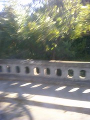
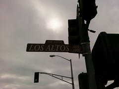
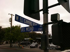
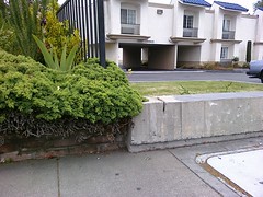
Los Altos doesn’t exist in a vacuum. For that mile and a half stretch of El Camino, the other side of the street is either Palo Alto or Mountain View. There is a spot on El Camino between Del Medio and Los Altos avenues where Los Altos, Palo Alto, and Mountain View all meet in a single point. No wonder it’s easy to lose track of where you are! The border between Mountain View and Palo Alto is marked only by the fence, bush, and break in the low wall in this photograph. Really they are the property line between the Country Inn Motel (Palo Alto) and The Hotel Aria (Mountain View), which used to be a Holiday Inn. Cryptically there is a signpost right here pointing to Los Altos (Avenue, that is) which takes on new significance.

Numbers Game

Granted, maybe it doesn’t really matter to you what city you’re in unless you’re challenging the jurisdiction of the speeding ticket you just received from the other city’s Police Department. What really matters is the street address right? Well that’s where things get really crazy. Take a trip with me.

Say you’re on El Camino in Palo Alto, heading south. As you cross Arastradero Road you’re on the 4200 block of El Camino with even addresses on your right and odd addresses on your left. The addresses increase as you go. As we all know, one of the cornerstones of modern civilization is that even and odd addresses are on opposite sides of the street, and that street addresses are ordered monotonically. You pass the Crowne Plaza Cabaña Hotel at 4290 ECR which is the last Palo Alto address on that side. You cross Adobe Creek and your side of the street is now Los Altos, though the other side of El Camino is still Palo Alto. Still with me? Fear not because the addresses still make sense. Both sides are now the 4300 block; the Motel 6 Palo Alto on your left is 4301 and the Courtyard Los Altos on your right is 4320. (There are a lot of hotels here.) You roll on and cross Los Altos Avenue. You’re still in Los Altos on your side but as we said, soon the other side turns into Mountain View. Your side is the 4400 block but the other side, the Mountain View side, is suddenly 2700! What?! That’s right, the addresses take a quantum leap on that Palo Alto/Mountain View side of the street.

Remember that the border between Palo Alto and Mountain View lies between the Country Inn Motel and The Hotel Aria. They are neighbors, but here are their addresses:
CIMG0381 CIMG0379

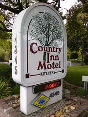
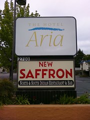
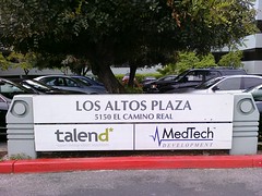
4345 El Camino in Palo Alto, 2700 El Camino in Mountain View, literally next door to each other. Not only  do the numbers jump, but the Palo Alto addresses are odd and the Mountain View addresses are now even. The Los Altos addresses on your side are also even. This is madness! But wait, there’s more. As you keep driving, your Los Altos addresses continue to increase, but your Mountain View addresses get smaller! They run in opposite directions. You get to the end of Los Altos and cross over into all-Mountain View a little past Rengstorff Ave. On your side the last Los Altos address is 5150 El Camino Real and their neighbor in Mountain View is 2065. Even addresses become odd. The 5100s become 2000s. Enough said.

CIMG0389 CIMG0385

This address nonsense used to trip me up from time to time. Back in the old days before online maps and GPS units, I would look up a business in the phone book (remember those?). Maybe I was going to El Torito at 4470 El Camino Real, Los Altos. (Don’t bother looking for it now; it’s gone.) If I made the mistake of approaching through Mountain View, the addresses around me would be no help at all—somewhere in the 2000s when I’m looking for 4470, and odd when I’m looking for even. This confusion is part of the reason I started AllCamino.com. I felt a need to understand these addresses and help my fellow sufferers. Don’t even get me started on West El Camino, East El Camino, South El Camino, and North El Camino.
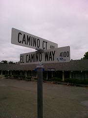
Reading Signs

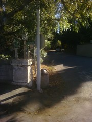
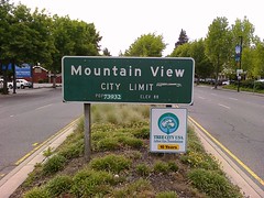
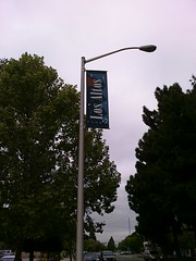
It’s not all bad. Even without wireless navigation technology there are plenty of hints to keep you oriented. There are well-placed “city limits” signs, and the light posts have handy civic banners hanging from them. Los Altos Patch Editor L.A. Chung pointed out a useful trick. Los Altos city street signs are brown and Mountain View signs are blue. I figured out on my own that Palo Alto signs are white, but the Palo Alto trash cans are blue.
CIMG0386 CIMG0398 CIMG0377 CIMG0374  CIMG0375 CIMG0378 CIMG0349

I still get lost on El Camino every now and then which is especially humiliating since I have this blog and all. Technology helps but I can’t always rely on it, so I’m learning that a little knowledge and good ol’ powers of observation go a long way. And if those fail me there’s always the last option of a desperate man: stopping to ask for directions.

The City with Heart

Monday, February 14th, 2011

When you start a blog about a street, you end up spending a lot of quality time in Google Maps. I have literally covered every mile of El Camino Real with my mouse, paging up and down the state. It’s a form of virtual tourism, a poor man’s hot air balloon ride giving me a bird’s eye view of my favorite road, one I can’t easily get any other way. I was doing just that a while back, mousing up the Peninsula towards San Francisco, when I spotted something that gave me pause: a heart-shaped neighborhood in San Bruno. It’s no accident. The cross street piercing the top like an arrow is called Cupid Row.


View Larger Map

The neighboorhood is subtly laid out with a pleasing graphical design. The heart itself is made of two streets, Carlton Ave and Terrace Ave, joined in a perfectly symmetrical valentine, dimpled at the top and pointy at the bottom. Cupid Row intersects it through its axis, continued by Texas Pl on the other side. It’s encased in the larger loop  of Florida Ave and Georgia Ave, and the whole thing is cleverly mirrored  by Taylor and Chapman avenues. The heart itself is not duplicated though. Kensington Ave and Garden Ave approximate it but lack the dimple. They form more of a shield shape with Mastick Ave, which opens up many possibilities for poetic interpretation. All this is just a block off El Camino Real opposite the termination of Crystal Springs Rd.

San Bruno is proud of  its romantic little secret. I found this article from circa Valentine’s Day, 2004 giving its history.

[SF Gate]

As it turns out the neighborhood was laid out on land formerly occupied by Uncle Tom’s Cabin, the longtime El Camino landmark rest stop on the Butterfield Stagecoach route. It’s not clear to me if the streets were created 100 years ago, or post World War II. The latter makes more sense. Perhaps the “Heart Area” was designed to attract newlywed returning G.I.s.

According to the article the Cupid Row tract inspired a motto for the city, “The City with Heart,” which implies a little dig at their Industrial neighbor to the north. El Camino has much to offer loving couples celebrating Valentine’s Day today—fine dining, flowers, candy, gifts, even secluded getaways. But San Bruno has really taken the holiday to heart, as they’ve taken it to the streets.

This post is dedicated to my own  true love. Happy Valentine’s Day, Paulette!

Under El Camino

Friday, December 10th, 2010

CIMG0248CIMG0247CIMG0246

InMenlo.com has published a really cool story about the El Camino Real bridge over San Francisquito Creek on the Santa Clara – San Mateo county line. There are several such bridges where El Camino crosses over all the creeks that flow out of the mountains into the Bay. They offer unique opportunities to literally get under the road and experience it from a completely different perspective. The creeks are frequented by the homeless and by graffiti taggers. Generally I’m not in favor of public graffiti, but tucked away down here it seems wholly appropriate. Click the headline below to read the article and see some of InMenlo’s celebrated photography.

Under Menlo: El Camino Real crosses San Francisquito Creek — InMenlo

Turn-by-turn

Thursday, December 2nd, 2010

CIMG1194

I’m still writing about the Shellmound Peace Walk. How did I end up there? I learned of the walk when my family and I went to the Gathering of Ohlone PeoplesIMG_2019 at Coyote Hills Regional Park in Fremont on October 3, 2010. We thoroughly enjoyed ourselves, watching traditional Ohlone dances, trying (and failing) to make fire, and learning all about Native life. One of the exhibit tables belonged to Indian People Organizing for Change (IPOC) and was staffed by Corrina Gould and Perry Matlock. They were promoting the Shellmound Peace Walk which immediately captured my imagination, especially when I found out they were going through Milpitas. I resolved to join the walk if logistics permitted.

Logistics permitted, so the morning of November 17 I left my car at the Great Mall and took public transit to Alviso Marina. I had a bit of a wait since all the other walkers were coming from the Oakland/Berkeley area and were stuck in rush hour traffic. I didn’t mind; it was a beautiful, sunny morning out on the Marina and I quietly contemplated the views of the water, tule marsh, and the Valley hills until everyone arrived.

Corrina explained to us the significance of Alviso: that her Ohlone ancestors lived there and collected salt for trade. (The Alviso salt ponds continued to be a major commercial operation up until pretty recently.) When the Spanish rounded up Indians they used Alviso as a collection point before marching them to Mission San Jose so our Peace Walk that day was approximating their trail.

We set off. Our route took us from the Marina down First Street, towards Tasman. Earlier that morning I had sent a tweet to Adelaide Chen of Milpitas Patch to let her know the Walk was coming through, and I was delighted she came out to meet us on First Street. I recognized her from her profile photo and introduced myself, and she was a great sport, walking along with us while we chatted. She commissioned me to write the article for Patch, which was an unexpected opportunity. I was a little hesitant because I envisioned myself later that evening furiously pounding out the article on my laptop while soaking my feet in an Epsom salt bath and I was worried about possible electrocution hazards, but I accepted. She gave me some quick journalism tips which were a big help because I would have been stuck after who/when/where/why/what’s-for-lunch. My new assignment colored the rest of my day though because now I had real responsibility, and I felt I had to inform everybody that the casual conversations we had been having were now “on the record.”

We turned up Tasman, passing through Cisco land. We took a break on a patch of grass in front of a Cisco building where we were questioned by some Cisco employees, probably plainclothes security. I suspect they wanted to make sure we weren’t protesting them, but they were happy when Corrina told them we were just passing through. It was strange being here because I work very nearby, so reflecting on ancient peoples in the midst of all the high-tech companies that comprise my world now was a jarring juxtaposition. Crossing Coyote Creek into Milpitas grounded me because the creek has special significance to me. I live and work close to it, and it’s a constant feature I’ve seen on many old maps so it helps me link the past and the present.

The next point of interest for the Walk was Elmwood Correctional Complex, former site of an Ohlone shellmound. As we passed we could hear the shouts of inmates; I don’t know if they were shouting at us, for us, or if they even knew we were there. Our group said prayers and dropped tobacco—traditional medicine—for the spirits of the dead. Turning up Abel we walked along the culvert that used to be Penitencia Creek and marveled at a number of majestic blue herons gathered there. I could see the Jain Center on Main Street and thought about how this spot is a spiritual nexus for Milpitas. The Ohlone buried their dead here, and the Franciscans gave penance here, giving Penitencia Creek its name. I remarked on the irony of passing Serra Center, a strip mall named for Father-President Junipero, considered by many to be a symbol of Indian oppression. His 297th birthday happened to be exactly one week later, November 24.

We rested again outside Carl’s Jr. and IPOC co-founder Johnella LaRose gave us some history of the Walk and its roots in 1978’s The Longest Walk and its connection to numerous international Peace Walks for varied causes such as nuclear non-proliferation. I interviewed Jun Yasuda, the Japanese Buddhist nun heading our procession, to understand her dedication to Native American causes. She explained to me that as a Buddhist she is drawn to confront human suffering such as the Indians endured through history. Also she sees traditional Native selflessness—putting the community ahead of one’s self—as compatible with Buddhist teaching and a way forward for mankind to Peace. Maybe Columbus was onto something when he confused the so-called “Indians” of the “New World” with residents of India, birthplace of Buddhism.

The rest of the trek was a long haul up Abel to Milpitas Boulevard and Warm Springs. We were supposed to turn onto Mission Boulevard and end at Mission San Jose but our late start caught up with us so we ended the day at Booster Park in Fremont. IPOC provided food fixin’s and I made myself a peanut butter, jelly, and corn chip sandwich. After a ten-mile walk I think officially it was The Best Sandwich I ever tasted. My feet were tender and my thighs ached (as much from the barbell lunges I did in the gym the day before as from the walk) and I was more than a little damp from the unseasonably warm weather, but it was all worth it. We sat in a circle and several in the group shared their thoughts and feelings on the day.

I had planned to take a bus back to the Great Mall but I ended up catching a ride with a driver who kindly shuttled those who had to retrieve vehicles left in Alviso. It was astounding how quickly we got back, retracing by car in minutes the route it took us hours to walk. Modern transportation is a gift, but being able to complete the walk, even for just one day, was a blessing.

Ridin’ on the Green Line

Saturday, November 13th, 2010

CIMG0654

Early November I started noticing something new on my street: Santa Clara Valley Transportation Authority’s Route 66 is now being serviced by shiny new hybrid buses. They’re hard to miss with eye-catching “Hybrid” labels on the sides, a reworked VTA logo with a new green swoosh around it, and a big boxy hump on the roof.

I went to VTA’s web site to check them out and learned that VTA is purchasing a “fleet of 90 American-made, low-emission diesel electric hybrid buses.” The cool thing is they used federal stimulus money as well as California Prop 1B funds to buy buses that are built by a company nearby in Hayward, creating and preserving green jobs here in the Bay Area: your tax dollars at work. The new buses are 90 percent cleaner and emit 15 percent less greenhouse gas than the nineties-era all-combustion coaches they replace.

I love that Route 66 is the first to get these new buses. This route is the historic “El Camino de San Jose”  bus line, coming up through San Jose on Monterey Road from the south, continuing onto First Street through downtown, then cutting over to Oakland Road and Main Street in Milpitas. After a few twists it terminates at Dixon Landing and North Milpitas Boulevard, at the county line. This bus was the first one I took on both my epic bus trips up and down El Camino Real.

CIMG0680All the new hybrid buses I had seen were similar to the old diesel-only ones—white paint jobs with blue and red stripes down the side. Earlier this week though I was driving on Oakland Road and I saw something completely different: a hybrid bus with a brand new colorful full-body wrap! It was gorgeous, depicting a blue sky, a field of golden poppies, and native California wildlife. I desperately wanted to take a picture of it so I rashly made the decision to “follow that bus!” How hard could that be? It’s a bus that stops, right? It turns out I’m really bad at trying to front-tail a bus. I raced ahead of it (obeying all speed and traffic laws, of course) and pulled over to snap a shot of it, but I kept messing up the timing.CIMG0653 At one point I pulled way ahead of the bus into a parking lot and parked…behind a hedge. D’oh! After a couple more botched attempts I decided to go for the sure thing. I got behind it and followed it to the Great Mall where I know it waits for several minutes. Brilliant. Then I was separated from it by a red light. C’mon! C’mon! When I got to the mall it was still there. Awesome. Park, get out of the car, and bam, off it goes again. Augh!!! Back in the car, I tried to catch it at the Milpitas Library but failed to find a good ambush spot. Vroom, it’s gone. Sunnyvale biscuit! I’m no quitter. Undeterred I pulled ahead, determined to find a good spot, but I had a problem. I didn’t know the route past the library, and I didn’t have time to pull up the map on my smartphone. I literally had to sniff out the route, hopping from bus stop to bus stop. I felt like a caveman tracking a woolly mammoth (with fewer emissions). I lucked out and guessed correctly that it turns off Jacklin onto Escuela. I tried to trap it at the end of Escuela but again it eluded me because I couldn’t park close enough. By then I was literally shaking with frustration at the absurdity of it all so I just followed it until it finally came to rest at the end of the line. I parked in the Sunnyhills Apartment complex of all places. I had all the time in the world so I got my shots. Victory. I have no idea what the driver on break thought of the crazy guy stalking him from San Jose and taking tons of pictures of his bus, so I simply told him I was admiring the new paint job, and he understood that.

CIMG0655

CIMG0661

CIMG0657

CIMG0656CIMG0658

I should mention that going southbound, Route 66 goes to South San Jose all the way to Santa Teresa and terminates at Kaiser Permanente San Jose Medical Center. The street it turns onto to get to the hospital is Camino Verde. “Green Road.” Kinda perfect.

CIMG0662

Sunnyvale Bike Party

Friday, October 1st, 2010

Sunnyvale Bike Party

[Update] Whoa, I goofed big time. I posted details for last month’s ride, September 3. I don’t know if there’s a ride on Friday, October 1. If you’re interested, you might want to give the Sunnyvale Art Gallery a call first to confirm.

Yep, you read that right. Sunnyvale has its own Bike Party and the third one is happening this Friday, September 3, 2010. It embarks at 8:00 PM on El Camino Real at the Sunnyvale Art Gallery, which sponsors the ride.

Sunnyvale Bike Party bills itself as the “smaller, gentler” bike party, a clear reference to San Jose Bike Party which has been a victim of its own rapid growth the past couple months. The San Jose ride has become so large that they’ve had problems like drunken and disorderly riders, complaints from neighbors, and riders breaking laws by blocking lanes and running red lights. In August a rider was seriously injured when he collided with an SUV on Lawrence Expressway. Witnesses said the cyclist had run the light, and paid the price.

I think there’s room in the Valley for the two rides, the established juggernaut and the startup. San Jose’s ride is the third Friday of the month and Sunnyvale’s is the first so there’s no conflict there. However the Sunnyvale ride does coincide with San Jose’s South FIRST FRIDAYS art walk so for that one night you’re forced to choose between bicycles and art. It’s a nice dilemma to have.

Sunnyvale Bike Party #3

Friday, September 3 · 8:00pm – 10:30pm
Sunnyvale Art Gallery
251 West El Camino Real
Sunnyvale, CA
Got a Bike? Come ride!
Facebook

Child Safety Event

Thursday, September 23rd, 2010

John WalshDNA LifePrint is holding a Child Safety Event this Saturday, September 25, 2010 from 9:30 AM until 2:00 PM at Sunnyvale Ford on 650 E. El Camino Real. Sunnyvale Ford is underwriting the event, which is free to the public. Parents can bring their children by to have them digitally fingerprinted (digital digits?) and photographed and receive a child safety kit to take home. DNA LifePrint is endorsed by John Walsh, child protection advocate and host of TV’s “America’s Most Wanted.”

Significantly the take-home kit includes a DNA identification kit. You use it to sample the child’s DNA and store it along with the photo, fingerprints, and other identifying information. In the unthinkable event of a child going missing, the whole kit can be handed over to law enforcement, saving precious time and giving them tools they can use immediately in their investigation. My understanding is that the parents retain all of the gathered information; DNA LifePrint and Sunnyvale Ford don’t keep or database anything, not even a record of your visit, so your privacy is protected. I for one am not comfortable with the idea of a car salesman knowing my family’s genetic predilection for sunroofs, leather seats, and hassle-free financing.

I believe they try to create an event that’s fun and educational for kids, typically with refreshments, entertainment, and appearances by local police, fire, and emergency medical personnel. An interesting fact about the Sunnyvale Department of Public Safety is that the single organization fills all three roles. Their Public Safety Officers are cross-trained and are ready at any time to solve a crime, put out a fire, or provide emergency medical care, literally depending on which hat they happen to be wearing.

The DNA LifePrint Child Safety Event

Saturday, September 25 · 9:30am – 2:00pm
Sunnyvale Ford
650 E. El Camino Real
Sunnyvale, CA 94087
Facebook Page

Sunnyvale Ford Lincoln Mercury is Proud to Host The DNA LifePrint Child Safety event.

LifePrint is a New Biometric fingerprinting & DNA identification Kit for children that provides Parents with the vital tools recommended by the FBI and the department of Justice if the child becomes missing.

Parents, Please bring your children to this FREE child safety event. and please feel free to share this invite with other families and parents you know.

Free FBI Certified Biometric 10 Digit Fingerprint Profile,
Free High resolution full color Digital photograph of your child
Free Child safety journal.
Free Home DNA identification kit.

Old Counting Road

Monday, September 20th, 2010

CIMG0176

Sorry, I didn’t mean to leave you hanging. As I completed my reverse bus trip down El Camino Real earlier this month I tallied many chain stores like fast food restaurants and grocery stores as well as other categories like gas stations and bike shops. I also kept track of every El Camino Real bell. I tallied everything on the southbound trip, but I didn’t count them until now. Here are the totals for both the southbound trip and the northbound trip last November. I got some nice results.

Name

East Bay East

Peninsula East

Peninsula West

Peninsula Total

Gas Station 4 24 23 47
El Camino Bell 1 25 18 43
Subway 2 5 8 13
Taco Bell 2 7 4 11
Jack in the Box 0 7 3 10
McDonald’s 3 1 9 10
Safeway 2 5 4 9
Blockbuster 0 7 1 8
Kragen 0 5 3 8
Burger King 1 5 2 7
KFC 0 5 2 7
Bicycle shop* 0 5 1 6
Lucky 0 4 2 6
Carl’s Jr. 0 2 2 4
Togo’s 0 2 2 4
In-n-Out Burger 0 0 2 2
The Off Ramp 0 2 0 2
Wendy’s 0 0 2 2
Midas* 0 0 1 1

* Under-counted due  to inconsistent counting between trips

On every leg of the trip I only looked out the windows on the right side of the bus so I only saw one side of the road. The East Bay East column counts the businesses I passed heading north from San Jose to the Fremont BART station. It’s a short trip so the counts are low. I only made the trip in one direction so I only counted the east side of the road; I don’t have counts for the west side of the road at this time. The Peninsula East and West columns are for the long rides between San Jose and San Francisco. On the northbound trip I looked at the east side of the road, and southbound I looked west. The Peninsula Totals column is just that and does not include the East Bay counts. The main anomalies are bicycle shops and Midases because I didn’t count them consistently between the two trips so I know they are underrepresented in my table.

CIMG0229 I’m delighted to see that bells are pretty much at the top of the list, outnumbered only by conglomerated gas stations regardless of brand.  The original vision of the bell marker project in 1906 was to place them one mile apart on El Camino Real. It’s a 50-mile trip from San Jose to San Francisco and I counted 43 bells. There’s room for plenty more since I only saw one bell in San Francisco. It’s amazing how faithful Caltrans and the California Federation of Women’s Clubs have been to that original vision.

In the food department I’m surprised to see Subway at the top of the list with 13 stores though I shouldn’t be since they really do seem to be everywhere. I remarked on the northbound trip how there were 7 Taco Bells but only 1 McDonald’s. The southbound trip equalized the disparity with 4 Taco Bells but a whopping 9 McDonald’ses. Taco Bell still edges out McDonald’s with a total of 11 to 10, but that’s within the margin of error. The weird thing is how Taco Bell dominates the east side and McDonald’s dominates the west. The bell and the arch; the perfect symbols for the modern mission road.

My picks for which businesses to count were arbitrary.  I don’t know why I didn’t count Starbucks; I regret the omission. On the southbound trip I wished I had been counting Walgreens and CVS drugstores because I saw a lot of them. Another unusually frequent chain was Holiday Inn Express. I think I saw half a dozen on the southbound trip alone. Car washes, car dealerships, hotels, and banks would also have been interesting to count.

The purpose of this is to embrace the vast stretches of El Camino which are zoned as commercial strip and celebrate the beauty in their homogeneity. They are home to pretty much every national and regional brand I can think of. Even so all these chain stores combined are a drop in the bucket. El Camino as I saw it is made up primarily of small businesses of every description from mom & pop dry cleaners to favorite local chain eateries. There are also homes, schools, municipal buildings, and open space. I can try to reduce this Royal Road to simple numbers, but the whole will always be greater than a count of its parts.